
Figure 1. Map of the Azul region showing the location of the sampled points.
Figura 1. Mapa de la región de Azul con la localización de los puntos de muestreo.
HEAVY METAL BACKGROUND LEVELS IN RURAL SOILS: A CASE STUDY IN PAMPEAN SOILS (ARGENTINA)
NURIA ROCA1-2*
1 Facultad de Agronomía, Universidad Nacional del Centro de la Provincia de Buenos Aires, CC 47, 7300 Azul (Argentina)
2 Facultad de Biologia, Depto. Biologia Vegetal, Universidad de Barcelona (España), Av. Diagonal 643, 08028 Barcelona (España)
*Autor de contacto: nuria@faa.unicen.edu.ar
Recibido: 29-09-14
Recibido con revisiones: 21-04-15
Aceptado: 05-06-15
ABSTRACT
Azul, an agricultural county at the center of Buenos Aires province, Argentina, was proposed as a reference for heavy metal background levels. These levels will be used to identify and assess soil pollution processes at the regional level. Forty-two top soils were sampled and heavy metals contents were analysed for seven elements (Cd, Co, Cr, Cu, Ni, Pb, and Zn) with an inductively coupled plasma-mass spectrometer (ICP-MS) after acid digestion. Considering the need to find a simple and robust statistical test, three methods (4o-outlier test, iterative 2o-outlier test and calculated distribution function) were used. The upper limits of the background ranges were expressed in mg kg-1: Cd 0.15, Co 10.8, Cr 22.1, Cu 39.2, Ni 13.7, Pb 11.8 and Zn 133.9. Once the background upper limits were established, a few points with anthropic signatures were observed. Cd was the heavy metal which showed the greatest number of samples with enrichment anomalies. The greatest enrichment anomalies in Cd, Cr, Cu, Ni, Pb and Zn were detected in grassland top soils due to an unauthorized rubbish dump. The slight anomalies in crop lands could be due to an incipient anthropic contamination.
Key words. Background, trace elements, soil pollution, anthropic sources.
NIVELES BASALES DE METALES PESADOS EN SUELOS RURALES: UN CASO EN SUELOS PAMPEANOS (ARGENTINA)
RESUMEN
En este trabajo se proponen valores básales en el municipio de Azul (Argentina), una zona de uso agrícola-ganadero representativa en Sudamérica, como base para detectar e identificar la contaminación de los suelos a nivel regional. Se muestreó el horizonte superficial de cuarenta y dos suelos, se realizó una digestión ácida y, posteriormente se analizaron siete elementos (Cd, Co, Cr, Cu, Ni, Pb y Zn) con un espectrómetro de plasma de inducción acoplada (ICP-MS). Se comprobó la eficacia de tres pruebas estadísticas (4a-outlier test, iterative 2a-outlier test and calculated distribution function) para definir los valores de referencia. El límite superior de los niveles basales en mg kg-1 fueron: Cd 0,15, Co 10,8, Cr 22,1, Cu 39,2, Ni 13,7, Pb 11,8 y Zn 133,9. Una vez establecido los valores basales, se detectaron puntos con indicios de contaminación antrópica. El metal pesado que mostró anomalías en mayor número de muestras fue el Cd. Los horizontes superficiales de antiguos vertederos no controlados presentaron anomalías en Cd, Cr, Cu, Ni, Pb y Zn. Las anomalías detectadas en los suelos agrícolas podrían señalar una incipiente contaminación antrópica a nivel regional.
Palabras clave. Niveles basales, elementos traza, contaminación de suelos, fuentes antrópicas.
INTRODUCTION
Soil is a key natural resource which supports life and is a major pre-requisite for sustainable development in terrestrial environments (Sultan and Shazili 2009). Knowledge of background values of heavy metals in soils is necessarybefore a soil can be declared to be contaminated. These values can be defined as the natural content of heavy metals in soils without human influence (Salminen & Gregorauskiene, 2000). The term "geochemical baseline'' indicates the actual content of an element in a surface environment at a given point in time, as defined by Salminen and Gregorauskiene (2000) and considering the entrance of these elements to soils by diffusion (Adriano, 2001). Therefore, baseline values are not always true background levels (Mico et al, 2007). In particular, baseline values in agricultural soils correspond to total contents of heavy metals in soils not influenced by point input due to local human activities (eg, industries) but include diffuse or nonpoint input (e.g., atmospheric deposition, fertilization) (Holmgren et al, 1993). The determination of background values (as geogenic natural content), in contrast to baseline values, is crucial when defining the extent of contamination in areas where environmental legislation has not yet established intervention limits for all environmental matrices (Albanese et al., 2007).
Different approaches have been used to establish the background levels of trace elements in soils. Methods are usually classified into direct (empirical or geochemical) or indirect (statistical) and both can be combined leading to integrated methods (Dung et al, 2013). In direct methods, the background concentrations are obtained from normal content reported in the literature or analysing samples representing pristine areas. Difficulties arise when different soil types and extraction procedures are used. Furthermore, the geochemical background changes regionally with the basic geology as well as with the lithological and geochemical nature of the bedrock. Different measurements at varying depths in the soil (vertical comparison), such as a high content on surface horizons and a downward trend in the profile, can confirm the hypothesis of an anthropic accumulation. However, the comparison is effective only when the chemical composition of the soil does not vary significantly with depth, and when there are no intrasolum translocations, erosion processes, truncation, colluviation or burial of the element within the soil. An indirect method is the comparison between a given soil type in an uncon-taminated site, and the same type of soil at a site receiving anthropic inputs (horizontal comparison) (Bini et al, 2011). Indirect methods or statistical approaches consist in sampling a large number of sites and involve using statistical tools and spatial analysis to separate, within a data set, the background concentration from that related to anthropic sources. Samples identified as polluted can be single ormultiple outliers or a population itself. Considering the need to find a simple and robust statistical test, three methods (4o-outlier test, iterative 2o-outlier test and calculated distribution function) were used and discussed to establish the reference or background levels. Naturally and anthropogenically-induced processes not only lead to a widening of the range of the data collective (larger standard deviations), but also to multi-modal distributions. Ideally, each mode corresponds to a relevant process with its underlying normal distribution (Matschullat et al, 2000). The objective of the applied methods in this study is the elimination of potential outliers from the data set. These outliers will have to be detected and eliminated as fingerprints for processes disturbing the normal data distribution (Matschullat et al., 2000). Therefore, the resulting sub-collective (free from outliers) is defined as reflecting background conditions.
Qualitative and quantitative heavy metal content data from Argentine soils is scarce. Recently, Roca et al. (2012) determined the background levels of several heavymetals in soils of Catamarca province, located in north-western Argentina, and Lavado et al. (2004) determined the baseline levels of potentially toxic elements near Buenos Aires. The humid Pampean Region of Argentina is essentially a very wide plain of 300 000 km2 characterised by a humid temperate climate and grassland natural vegetation, which is one of the largest temperate cropland areas in the southern hemisphere. However, despite the flat landscape, many detailed soil surveys show a great lateral variability in the diagnostic properties over very short distances, which indicates a complex and contrasting soil spatial distribution pattern in the Pampean plain (Blanco & Stoops, 2007). Despite the close relationship between soil and rock, soil forming processes modify the regolith and redistribute the content of heavy metals in soil horizons (Zhang et al, 2002). Moreover, the central Pampean plain has undergone a great agricultural intensification, increasing production in more than 106% in the last three decades (Requesens, 2008).The agricultural system in Azul, with a total area of 680,000 ha, includes annual grain crops (207,394 ha) and pastures (77440 ha) (Requesens, 2008).
Sustainability of conventional agriculture is based on a high input of agrochemicals, such as phosphate fertilizers.
Conventional inorganic phosphorus fertilizers may cause an inadvertent addition of heavy metals, which are contained as impurities. Giuffré de López Camelo et al. (1997) state that continuous fertilization of soils could increase the heavy metal contents exceeding natural abundance in soils, and transfer of these metals to the human food chain must not be overlooked. The topsoil layer is of particular interest as degradation may occur due to atmospheric deposition or anthropogenic activities (Aelion et al., 2008). These concerns are very important in the Argentinian agricultural system with a traditionally environment- friendly image with relatively low agrochemical inputs. Other anthropic land uses could be present in soils around residential areas or between cropped lands and grazed grasslands as rubbish dumps, occupying small areas but with a great impact on the environment. These mosaic of unauthorized rubbish dumps increases the risk of soil pollution. Colangelo et al. (2005) demonstrated contamination with Cd, Cr, Pb and Zn in soils near a rubbish dump located in Buenos Aires, province in Argentina. However, their respective contents did not surpass the recommended values for different uses according to national environmental laws.
This study aims at (1) establishing background content levels for seven metals in top soils of an agricultural area (Cd, Co, Cr, Cu, Ni, Pb and Zn) using different statistical approaches and (2) assessing the degree of surface soil pollution and identifying the local sources of pollution.
MATERIAL AND METHODS
Area description and sample collection
The study area is located in the municipal district of Azul, Argentina. The parent material of the soils of the entire Pampean Region is the denominated Pampean loess, a thick mantle of sediments of the Quaternary age that filled and levelled the irregularities of an older Tertiary relief. In the SSW and NNW, the landscape is slightly rolling with less than 2% slope. Luvic Phaeozems and Luvic Petrocalcic Phaeozems (IUSS Working Group WRB 2014) are considered as the most prevalent soil in the Rolling Pampa. In the NE, the landscape is characterized by a flat plain with regional slopes of less than 0.5%. Mollic Solonetz and Haplic Solonetz (IUSS Working Group WRB 2014) are considered as the most prevalent soil in the Flooding Pampa (Roca & Pazos, 2002). In the SSE of Azul municipal district, there is an area with Precambrian and Paleozoic gneiss and migmatite outcrops that conform the wider system of Pampean Sierras, with slopes and intermountain areas covered by loess. Endoleptic Phaeozems, Luvic Phaeozem (Skeletic) and Luvic Petrocalcic Phaeozem (Endoskeletic) (IUSS Working Group WRB, 2014) are considered to be the most prevalent soils in the Pampean Sierras (Roca & Pazos, 2008).
The native grasslands are organized in relatively extended, discrete patches because of the smooth topography of the area, and Paspalum quadrifarium L. grasslands, typical of moist environments, are predominant from low areas to moderately high convexities. The dominant species of the grass-legume mixed pasture are perennial rye-grass (Lolium perenne L.) and white clover (Trifolium repens L.), with minor coverage of red clover (Trifolium pratense L.), bromegrass (Bromus catharticus L.) and tall fescue (Festuca arundinacea S.).
Forty-two plots from crop lands, grazed grassland and soils from Azul Sierras were sampled. In each plot, eight subsamples of the A horizon were taken and subsequently mixed. The area covered for the soil sample collection was approximately 6615 km2 and ranged from 36°15' S to 37°21' S and from 60°08' W to 59°05' W. The sampling sites are shown in Figure 1.
Determination of metal content
To determine the heavy metal content, approximately 3 g (to the nearest 0.001 g) of the air-dried and ground soil samples with particle sizes <150 |im were transferred to a 250 mL reaction vessel. After moistening, 21 mL HCl and 7 mL HNO3 were added as drops to reduce foaming. The samples were allowed to stand for 16 h at room temperature with a condenser connected. The reaction vessel was then heated at 116 °C under reflux conditions for 2 h, ensuring that the condensation zone was lower than 1/3 of the height of the condenser. After 2 h, the contents of the reaction vessel were filtered by gravity through Whatman no. 42 filter paper into a 100 mL graduated flask, using HNO3 to wash the reaction vessel (ISO/CD 11466, 1995). Cadmium (Cd), cobalt (Co), chromium (Cr), copper (Cu), nickel (Ni), lead (Pb) and zinc (Zn) were measured with an inductively coupled plasma-mass spectrometer (ICP-MS Perking Elmer Elaw6000). The detection limits for the analysed metals ions in mg kg-1 were 0.04 for Cd, 0.2 for Co, 0.4 for Cr, Cu and Ni, 0.1 for Pb and, finally, 1.0 for Zn. Quality control was ensured with duplicate analyses on all samples with reagent blanks. An Rh internal control was added to each sample for controlling accuracy and precision. The calibration curve for ICP measurements was made with NIST (National Institute of Standards and Technology) standard reference solutions. All ICP measurements were repeated three times, with standard deviations between measurements well below 5%. Soil samples were also measured for pH, organic matter (OC) and clay content using standard techniques: organic carbon content was determined by Walkley and Black titration method and soil acidity (pH) was measured in a soil-water suspension with a 1:2.5 ratio and was stirred for 30 minutes (Burt 2004).
Figure 1. Map of the Azul region showing the location of the sampled points.
Figura 1. Mapa de la región de Azul con la localización de los puntos de muestreo.
Statistical analysis
The background values were calculated using the 4o-outlier test, iterative 2o-outlier test and calculated distribution function (Matschullat et al., 2000). This calculation required the elimination of potential outliers from the data set and the calculation of the mean and standard deviation of the remaining subset. The normal range of a sample was defined by the upper values assessed by the mean +2o, which means that 97% of the samples were below this value. Only this type of data includes sufficient information about the natural scatter of the background values (Matschullat et al., 2000).
The contamination degree of heavy metals in soils was assessed with the geoaccumulation index (Igeo) introduced by Muller (1969), taking into account the upper limit of background concentration determined as described before. The method has been widely employed in European trace metal studies since the late 1960s. It is also employed in pollution assessment of heavy metals in urban soils, urban road dust and agricultural soils from China (Wei & Yang 2010). The geoaccumulation index is computed using the following equation:

significance. The heavy metal distribution by soil use was tested by applying ANOVA. In addition, data were compared using covariance analysis (ANCOVA), with the organic carbon (OC) percentage and pH as the covariate (p < 0.05) (Neter et al., 1990). Pearson product moment correlation coefficients were calculated to examine the relations among the variables and PCA to explain most of the variance in the data while reducing the number of variables to a few uncorrelated components.
RESULTS AND DISCUSSION
Background determination
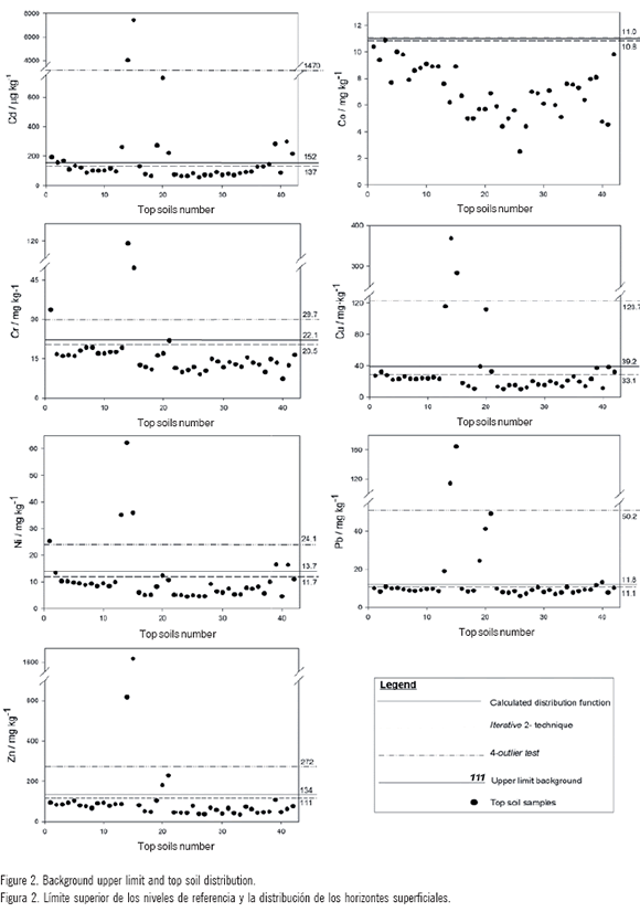
Table 1 shows the mean and median values of the original data set, the results from the fitted distribution (2a), the 4a-outlier test and the calculated distribution. The standard deviation (a) is given, as is the number "n" of single values within the collective/sub-collective and the relative loss of individual data points after respective fitting (data representation). Finally, the calculated upper limit (mean+2a) of the natural background content is given. Distributions are disturbed and skewed towards higher values. Lower values should, therefore, be free from anthropic influences. This, of course, is only partly true, because any kind of anthropogenically induced depletion, e.g., via acidification processes in soils, is being neglected here (Matschullat et al, 2000). The upper limits of the background content differ mainlybetween the iterative 2a-technique and the calculated distribution with respect to the 4a-technique. The iterative 2a-technique and the calculated distribution are better at reducing the background upper limit than the 4a-outlier test, with exception for Co (Fig. 2). It should be noted, however, that the values obtained from the 4a-technique by Roca et al. (2012) in Catamarca soils do not differ with respect to the iterative 2a-technique and the calculated distribution. The most plausible calculation of the geogenic background in the soils of the Humid Pampean Region was tested using the iterative 2a-technique and the calculated distribution. Therefore, the ranges obtained by the calculated distribution are chosen as background values. The upper limit of background values were expressed in mg kg-1: Cd 0.15, Co 10.8, Cr 22.1, Cu 39.2, Ni 13.7, Pb 11.8 and Zn 133.9. The soils have been predominantly influenced by natural element dispersion and accumulation processes, but there are a few points with an anthropic influence. The top soils of the eastern Pampas (Lavado et al. 2004) have content and dispersion values of heavy metals (in mg kg-1: Cd 0.92, Co 31.8, Cr 13.6, Cu 14.5, Ni 5.5, Pb 23.6 and Zn 50.0) that are similar to non-contaminated soils in other parts of the world, with Cd, Co and Pb seeming greater than that in our study.
Table 1. Statistical parameters for the top soil data set (mg kg4 and *u.g kg4) from the Azul region, and their variation according to three statistical tests to determine a natural background level.
Tabla 1. Parámetros estadísticos para los suelos superficiales (mg kg-1 and *u.g kg-1) de la región de Azul. Variación que se observan según los tres estudios estadísticos aplicados para determinar los valores de referencia.
|
*Cd |
Co |
Cr |
Cu |
Ni |
Pb |
Zn |
||
|
Mean |
406.1 |
7.1 |
18.1 |
40.4 |
11.2 |
17.6 |
124.6 |
|
|
Original data |
Median |
101.4 |
7.1 |
14.9 |
23.0 |
8.4 |
9.2 |
74.9 |
|
set |
Standard deviation |
1267.7 |
1.9 |
17.4 |
68.7 |
10.7 |
29.3 |
256.1 |
|
Number n |
42 |
42 |
42 |
42 |
42 |
42 |
42 |
|
|
Mean |
234.6 |
7.1 |
15.7 |
32.4 |
9.9 |
14.0 |
87.7 |
|
|
Median |
100.9 |
7.1 |
14.8 |
23.0 |
8.4 |
9.2 |
73.4 |
|
|
4a-outlier |
Standard deviation |
617.5 |
1.9 |
7.0 |
45.6 |
7.1 |
18.1 |
92.4 |
|
test |
Number n |
41 |
42 |
41 |
41 |
41 |
41 |
41 |
|
Loss (%) |
2.4 |
0 |
2.4 |
2.4 |
2.4 |
2.4 |
2.4 |
|
|
Upper limit |
1469.7 |
11.0 |
29.7 |
123.7 |
24.1 |
50.2 |
272.4 |
|
|
Mean |
91.5 |
7.1 |
14.2 |
20.1 |
7.4 |
8.9 |
67.6 |
|
|
Median |
88.0 |
7.1 |
13.9 |
20.2 |
7.7 |
9.0 |
67.6 |
|
|
2a-method |
Standard deviation |
22.7 |
2.0 |
3.1 |
6.5 |
2.2 |
1.1 |
21.5 |
|
Number n |
28 |
42 |
38 |
34 |
34 |
33 |
37 |
|
|
Loss (%) |
33.3 |
0 |
9.5 |
19.0 |
19.0 |
21.4 |
11.9 |
|
|
Upper limit |
136.8 |
10.9 |
20.5 |
33.1 |
11.7 |
11.1 |
110.5 |
|
|
Mean |
101.9 |
7.0 |
14.9 |
23.1 |
8.2 |
9.3 |
78.7 |
|
|
Calculated distribution |
Median |
101.9 |
7.0 |
14.9 |
23.1 |
8.2 |
9.3 |
78.7 |
|
Standard deviation |
25.1 |
1.9 |
3.6 |
8.0 |
2.8 |
1.3 |
27.6 |
|
|
Number n |
42 |
42 |
42 |
42 |
42 |
42 |
42 |
|
|
Upper limit |
152.0 |
10.8 |
22.1 |
39.2 |
13.7 |
11.8 |
133.9 |
Pollution assessment
Once the background upper limits were established, a few points with anthropic signs were observed (Fig. 2). The heavy metal showing the greatest number of samples with enrichment anomalies was Cd. The greatest enrichment anomalies in Cd, Cr, Cu, Ni, Pb and Zn were also detected in the top soil of sampled point numbers 14 and 15 (Fig. 2).
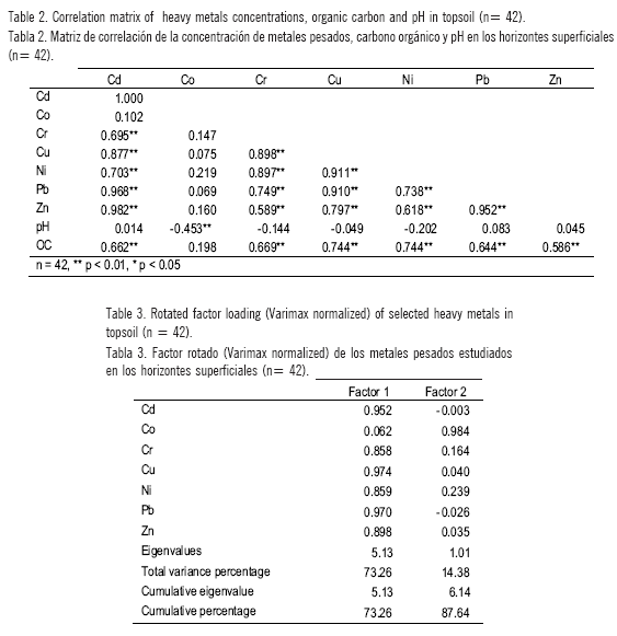
Multivariate statistics were applied to extract quantitative information about the origin and relationship of potentially toxic elements in soils (Boruvka et al., 2005). Correlation matrices are presented in Table 2. A large value strong correlation at p > 0.001 was obtained for top soil between all heavy metals, except for Co. The minimum significant correlation coefficient for p = 0.01 is 0.589 for the Zn-Cu pair. There are no significant correlations between topsoil Co and the other elements. Table 3 displays the factor loadings using Varimax rotation. The first two
main components were selected; they accounted for more than 88% of the total variation. The components were rotated using Varimax rotation. The loadings on the first component were large for Cd, Cr, Cu, Ni, Pb and Zn contents in top soils. The second component had large loadings for Co. The relationships between the heavy metals appear similar to the correlation matrices. A strong correlation between heavy metals, except for Co, suggests a similar chemical behaviour (Boruvka et al., 2005).
According to the Igeo ranking cited by Muller (1969), the level of pollution in the upper top soil of 2, 3, 40 and 42 points were non-significant. The Igeo values for the metals in soils with significant level of pollution are presented in Figure 3. In general, Co appears to be the least contaminant element in all top soils, while Cd and Pb show the highest I values for the two most contaminated points (N° 14 geo and 15). The most contaminated point (N° 14 and 15) is detected in a grassland soil with an unauthorized rubbish dump. This polluted area is located 10 km NW of Azul city, close to road N° 51 (36°43.60 S, 59°54.67 W). The two sampled points show the highest Igeo values for metals. The content levels of heavy metals in soil caused by unauthorized dumping are listed in the following order: Zn > Cu > Pb > Cr > Ni > Cd. It should be noted that the I geo for Cd is classified as heavily to extremely contaminated. The I for Cu, Pb and Zn also indicates moderate to heavy geo contamination. This indicates a significantly contaminated point for anthropic activities. It is indicated by Zhang et al. (1999) that the heavy metals contained in the soil of rubbish plots are Co, Cu, and Sb. However, in this study Co appears to be the least contaminant element in all top soils, including dump plots. In general, the abrasion of the machinery used to cultivate agricultural land, oil barrels or old cars are suggested as a potential source of heavy metals in these points.
The other polluted area is located around a municipal dump with a composting plant at Tapalque town (N° 19, 20 and 21), close to the boundary of Azul's municipal district. The I for Cd, Cu and Pb indicates slight to moderate geo contamination. However, pollution is probably due to an earlier unregulated storage system at the rubbish dump, and now the municipal treatment dump has a better organized storage system. Garcia et al. (2011), after over 10 years of accumulation of residues in dumps studied near Madrid, reported low or moderate Cu, Ni, Zn and Pb contents in the surrounding rubbish dump area.
In general, agricultural and grassland soils with anthropic signs appear to be the least contaminated soils in Cd and Ni (slightly to moderately contaminated). The diffuse contamination due to anthropic sources was relevant to two natural grassland soils (39 and 41 points). These included flooding events, where material rich in heavy metals may be carried from an upstream source and be re-deposited on flooded land further downstream. Moreover, the soils remain wet for long periods with a phreatic level close to the soil surface. This suggests more influence from anthropic activities than other natural grassland soils in a back slope position.
In addition to those warning signs, significant differences were also observed in all heavy metal contents, except for Pb, when using two types of land use: cultivated soil or grazed grassland (Table 4). Dongmei et al. (2011) also reported that land utilization is one of the important factors which affect the heavy metal contents of regional soil. For instance, all heavy metals were present at greater levels in cultivated top soil. When analysed by ANCOVA, with organic carbon content as the covariate and land use as a factor, the effect of the organic carbon was only significant for Cd and Cu. However, the differences between the various land use soils were still significant for all metals. When pH was used as the covariate, its effect was also significant for Cu and Co. However, the differences between the two land uses were still significant. Therefore, the organic carbon and pH, two important factors which affect the heavy metal contents and distribution, could not explain the greater levels in cultivated top soil. As some fertilizers and pesticides contain heavy metals such as Cd, Pb, and Zn (Kabata-Pendias and Murkherjee, 2007), the continuous application of these agrochemicals and other soil amendments potentially exacerbates the accumulation of heavy metals in agricultural soil (Huang & Jin, 2007). The most widely recognised contamination of inorganic fertilisers is associated with Cd present in the rock phosphate feedstock of all phosphate fertiliser materials (Nicholson et al., 2003). Wei and Yang (2010) also reported that the sources of Cd in agricultural soils in China may originate mainly from pesticides and fertilizers. Elberling eta/.(2010) established the enrichment with Cd, Cu, Pb and Zn of cultivated soils over the last 3300years in Europe. Although the agricultural history of Azul soil is less than 250 years, the study highlights the slight enrichment in some heavy metals, especially Cd. Therefore, that could be attributed to the use of fertilisers, fungicides or pesticides.
Table 4. Descriptive statistics of the heavy metal content (mg kg-1 and u.g kg-1), organic carbon and pH in land use groups (cultivated soil n = 10 and grazed grassland n = 20). For any given element within a column, values followed by the same letter do not differ at p = 0.05.
Tabla 4. Estadística descriptiva del contenido de metales pesados (mg kg-1 and *u.g kg-1), carbono orgánico y pH según los usos del suelo (suelos cultivados n = 11 y pasturas n = 21). Para cada elemento dentro de la columna, valores seguidos por la misma letra no difieren a p= 0,05.
|
Mean |
Standard Deviation |
Minimum |
Maximum |
||
|
Cd |
Cultivated soil |
125.14 a |
37.14 |
72.50 |
192.70 |
|
Grazed grassland |
88.04 b |
23.39 |
54.90 |
131.00 |
|
|
Co |
Cultivated soil Grazed grassland |
8.80 a 6.34 b |
1.37 1.75 |
6.10 2.50 |
10.90 9.80 |
|
Cr |
Cultivated soil Grazed grassland |
18.09 a 12.84 b |
5.59 2.52 |
11.70 9.00 |
33.70 18.10 |
|
Cu |
Cultivated soil Grazed grassland |
24.17 a 17.19 b |
4.20 5.16 |
15.30 10.10 |
32.10 26.40 |
|
Ni |
Cultivated soil Grazed grassland |
11.04 a 6.40 b |
5.04 1.72 |
6.00 4.50 |
25.30 9.40 |
|
Pb |
Cultivated soil Grazed grassland |
9.31 a 8.68 a |
0.88 1.16 |
8.10 6.00 |
10.90 10.70 |
|
Zn |
Cultivated soil Grazed grassland |
77.70 a 58.53 b |
19.26 18.24 |
39.80 34.80 |
103.80 93.00 |
|
C |
Cultivated soil Grazed grassland |
3.04 a 2.54 a |
0.57 0.78 |
2.01 1.29 |
3.82 4.43 |
|
pH |
Cultivated soil Grazed grassland |
5.81 a 6.87 b |
0.28 1.19 |
5.40 5.20 |
6.40 8.99 |
CONCLUSIONS
The background values were in mg kg-1: Cd 0.15, Co 10.8, Cr 22.1, Cu 39.2, Ni 13.7, Pb 11.8 and Zn 133.9. The studied soils were predominantly influenced by natural element dispersion and accumulation processes but there are a few points with an anthropic influence. In general, Co appears to be the least contaminant element in all top soils. The greatest soil pollution with Cd, Cr, Cu, Ni, Pb and Zn was detected in the grassland top soil due to an unauthorized rubbish dump. The other polluted area, located around a municipal composting plant on the boundary between Azul and Tapalqué, was probably due to a historic uncontrolled storage system. The slight diffuse enrichment of crop lands could be due to an incipient anthropic contamination.
ACKNOWLEDGEMENTS
The authors thank Mr. D. Ballarena, Mr. M. Schwab and Ms. G. Ponce from the Facultad de Agronomía of the Universidad Nacional del Centro de la provincia de Buenos Aires for their assistance in this study.
REFERENCES
Adriano, DC. 2001. Trace Elements in Terrestrial Environments. Biogeochemistry, Bioavailability and Risks of Metals. Ed. SpringerVerlag, New York.
Aelion, CM; HT Davisa, S McDermottb & AB Lawsonc. 2008. Metal concentrations in rural topsoil in South Carolina: Potential for human health impact, Science of the Total Environment 402:149-156.
Albanese, S; B De Vivo; A Lima & D Cicchella. 2007. Geochemical background and baseline values of toxic elements in stream sediments of Campania region (Italy). Journal of Geochemical Exploration 93: 21-34.
Bini, C; G Sartori; M Wahsha & S Fontana. 2011. Background levels of trace elements and soil geochemistry at regional level in NE Italy. Journal of Geochemical Exploration 109: 125-133.
Blanco, M del C & G Stoops. 2007. Genesis of pedons with discontinuous argillic horizons in the Holocene loess mantle of the southern Pampean landscape, Argentina. Journal of South American Earth Sciences 23(1): 30-45.
Borüvka, L; O Vacek & J Jehliéka. 2005. Principal component analysis as tool to indicate the origin of potentially toxic elements in soils. Geoderma 128: 289-300.
Burt, R. 2004. Soil Survey Laboratory Methods Manual Soil Survey Investigations Report No. 42, version 4.0, USA.
Colangelo, CH; LA Ferrari; JC Chaumeil; CA Seminario Correa & S Georgeri. 2005. The environmental impact of lead, chromium, zinc and cadmium present in rubbish dump. Journal of Analytical Toxicology 29: 454.
Dongmei, Y; Z Jiaogen; W Jihua; M Zhihong & P Ligang. 2011. Analysis of relations of heavy metal accumulation with land utilization using the positive and negative association rule method. Mathematical and Computer Modelling 54: 1005-1009.
Dung, TTT, V Cappunys; R Swennen & ND Pung. 2013. From geochemical background determination to pollution assessment of heavy metals in sediments and soils. Reviews in Environmental Science and Bio/Technology 12: 335-353.
Elberling, B; H Breuning-madsen; H Hinge & G Asmund. 2010. Heavy metals in 3300-year-old agricultural soils used to assess present soil contamination. European Journal of Soil Science 61(1): 74-83.
García, R; JA González; V Rubio; C Arteaga & A Galán. 2011. Soil contamination in dumps on the karstic areas from the plateaus (southeast of Madrid, Spain). Water, Air and Soil Pollution 222(1-4): 27-37.
Giuffré de López Camelo, L; S Ratto de Miguez & L Marbán. 1997. Heavy metals input with phosphate fertilizers used in Argentina. The Science of the Total Environment 204: 245-250
Holmgren, GGS; MW Meyer; RL Chaney & RB Daniels. 1993. Cadmium, lead, zinc, copper and nickel in agricultural soils of the United States of America. Journal of Environmental Quality 22: 335-348.
Huang, SW & JY Jin. 2008. Status of heavy metals in agricultural soils as affected by different patterns of land use. Environmental Monitoring and Assessment 139: 317-327
ISO/CD (The International Organization for Standardization). 1995. Soil quality - Extraction of trace metals soluble in aqua regia. International Standard ISO 11466.
IUSS Working Group WRB. 2006. World reference base for soil resources 2006. 2nd edition. World Soil Resources Reports No. 103. FAO, Rome.
Kabata-Pendias, A. & AB Mukherjee. 2007. Trace Elements from Soil to Human. Springer.
Lavado, RS; MS Zubillaga; R Alvarez & MA Taboada. 2004. Baseline levels of potentially toxic elements in Pampas soils. Soil and Sediment Contamination 13: 329-339.
Matschullat, J; R Ottenstein & C Reimann. 2000. Geochemical background -can we calculate it? Environmental Geology 39(9): 990-1000.
Micó, C; M Peris; L Recatalá & J Sánchez. 2007. Baseline values for heavy metals in agricultural soils in an European Mediterranean region. Science of the Total Environment 378: 13-17.
Muller, G. 1969. Index of geo-accumulation in sediments of the Rhine River. Geojournal 2: 108-118.
Neter, J; W Wasserman & MH Kutner. 1990. Applied linear Statistical Models, 3rd ed. Irwin Publisher, Homewood, IL.
Nicholson, FA; SR Smith; BJ Alloway; C Carlton-Smith & BJ Chambers. 2003. An inventory of heavy metal inputs to agricultural soils in England and Wales. The Science of the Total Environment 311: 205-219.
Requesens, E. 2008. Teoría ecológica y agroecologíca. Vínculos y proyecciones. Universidad Nacional del Centro de la Provincia de Buenos Aires, Tandil.
Roca, N & MS Pazos. 2002. The WRB applied to Argentinian soils: two case studies. In: E Micheli, FO Nachtergaele, RJA Jones and L Montanarella (eds). Soil Classification 2001. European Soil Bureau Research Report No.7, EUR 20398 EN. Pp. 191-197. Official Publications of the European Communities.
Roca, N & MS Pazos. 2008. Soils of Sierras in Azul. Abstract In: The International Conference and Field Workshops on Soils Classification (Santiago, Chile).
Roca, N; MS Pazos & J Bech. 2012. Background levels of potentially toxic elements in soils: A case study in Catamarca (a semiarid region in Argentina). Catena 92: 55-66.
Salminen, R & V Gregorauskiene. 2000. Considerations regarding the definition of a geochemical baseline of elements in the superficial materials in areas differing in basic geology. Applied Geochemistry 15: 647-653.
Sultan, K & NA Shazili. 2009. Distribution and geochemical baseline of major, minor and trace elements in tropical topsoils of the Terengganu River basin, Malaysia. Journal of Geochemical Exploration 103(2-3): 57-68.
Wei, B & L Yang. 2010. A review of heavy metal contaminations in urban soils, urban road dusts and agricultural soils from China. Microchemical Journal 94: 99-107.
Zhang, H; D Ma; Q Xie & X Chen. 1999. An approach to studying heavy metal pollution caused by modern city development in Nanjing, China. Environmental Geology 38(3): 223-228.